desplazamiento
Soil is one of our most powerful tools in the fight against climate change—but only if we can measure and scale its carbon-storing potential. At Boomitra, we’ve developed a cutting-edge way to do just that. By combining satellite imagery, artificial intelligence, and an unparalleled archive of physical, georeferenced soil data, we’ve created the first remote sensing solution for monitoring soil organic carbon (SOC) at scale to be approved by Verra, the Social Carbon Standard, and a growing number of compliance standards.
This blog offers a closer look at our platform, answering key questions carbon credit buyers ask when evaluating remote sensing-based monitoring, reporting, and verification (MRV) systems.
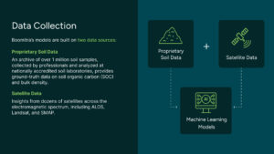
Boomitra’s AI-driven soil carbon models are built on two foundational datasets:
Our models are grounded in an extensive, globally sourced archive of over 1 million georeferenced soil samples, analyzed using standardized, internationally recognized lab methods and backed by robust metadata. For example, in India our URVARA project leverages government-issued soil samples from the Soil Health Card program, collected through standardized protocols at accredited district-level labs. Many soil datasets that we use also have both SOC and bulk density measurements made for the same soil sample—both parameters are necessary for the computation of soil carbon stocks in units of carbon mass per unit area.
Our datasets cover temperate, tropical, subtropical, and semi-arid zones, with representation across diverse soil types. We stratify by soil type and climate zone to ensure each agroecological region in our projects is appropriately represented.
Each sample is tagged with precise spatial coordinates, timestamps, sampling depths, and lab analysis method identifiers, enabling us to pair them accurately with satellite imagery for calibration. All samples are subjected to rigorous quality control filters, outlier detection, and harmonization processes to minimize measurement noise and inter-lab variability. By using large-scale, diverse datasets and selectively incorporating only high-confidence records, we are able to calibrate models that perform well across broad regions while still capturing local variability.
Our system integrates multi-year, multispectral, and radar-based observations from a curated set of high-resolution remote sensing satellites, like ALOS-2 (SAR), Sentinel-1 (SAR), Sentinel-2 (VIS/IR), Landsat, SMAP, and SMOS. These platforms provide both active and passive data streams capturing key spectral signatures that are causally related to SOC, moisture content, and bulk density.
Unlike coarse global averages or interpolated datasets, our approach matches pixel-level satellite data to precisely geolocated soil sample points—ensuring satellite-measured features correspond to specific ground-truth conditions. For example, L-band radar (e.g., from ALOS-2) penetrates surface vegetation to measure soil dielectric properties affected by SOC and porosity, while visible and infrared bands from Sentinel-2 and Landsat capture vegetation and surface characteristics, whose incorporation improves the overall accuracy of the measurements.
We apply rigorous cloud and shadow masking, atmospheric correction, and temporal filtering to isolate clean, seasonally appropriate satellite images. We target low-moisture windows to reduce confounding variables, since soil moisture can influence the soil’s backscattering properties. For every sample, data is drawn from multiple dates and satellite sensors to form a rich, high-dimensional covariate space, increasing model stability and transferability.
This comprehensive, multi-source satellite dataset enables project-scale MRV with both spatial granularity and temporal consistency, allowing us to capture SOC changes across highly variable landscapes and cropping systems.
This blended approach enables our models to detect patterns and relationships between what satellites see and what the soil actually contains. By combining these massive datasets, Boomitra’s machine learning models accurately estimate SOC at scale across diverse landscapes.
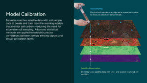
At the heart of our system is a powerful AI calibration process. Each soil sample in our dataset is matched with satellite observations from the exact time and location it was collected. These matched data points, or “paired observations,” feed into our machine learning models, training them to recognize how SOC levels influence satellite signals.
To ensure confidence in our predictions, we use geospatial Bayesian uncertainty analysis to rigorously validate each model. This means testing our models on independent datasets they’ve never seen before to evaluate accuracy, identify blind spots, and quantify uncertainty. As new soil and satellite data become available, the models improve—continuously learning and refining their predictions.
The result: a highly accurate map of soil organic carbon that can be generated quickly, affordably, and across massive geographies.
Uncertainty is an inherent component of any soil carbon measurement and modeling effort, and we address it through a conservative approach. We quantify uncertainty at multiple stages—from the performance of our predictive models to the propagation of that uncertainty at the project scale—using both empirical validation and statistical methods recommended in scientific literature and carbon accounting standards.
When comparing our remote SOC measurements with soil sampling validation datasets, results consistently show an R² between 40–60%, which aligns with published benchmarks for remotely sensed soil properties. These values are derived from independent validation datasets that the model has not seen before, ensuring they reflect real-world predictive accuracy rather than training performance.
At the project level, when uncertainty is propagated for large-scale projects, the result is approximately 1 tCO₂e/acre change uncertainty. To uphold conservative crediting, we apply an uncertainty deduction directly to the total credits issued. This deduction typically ranges from 10% to 30%, depending on project-specific conditions and uncertainty levels, ensuring that buyers receive credits backed by high statistical confidence.
In addition to AI-based monitoring, Boomitra incorporates biogeochemical modeling to simulate belowground carbon processes to calculate SOC stocks for periods between the satellite-based measurements. Carbon projects require regularly available SOC stock projections—both between observations and for periods without direct sensing (e.g., historical baselines and forward forecasts). Specifically, we apply the Rothamsted Carbon (RothC) model, an industry standard. This model estimates changes in SOC by simulating organic matter inputs and decomposition dynamics under various environmental conditions.
Key features of our biogeochemical modeling approach:
Carbon inputs: Includes crop residues, root turnover, litter, and organic amendments
Environmental drivers: Monthly temperature, precipitation, soil texture, pH, and bulk density from sources like ERA5 and national datasets
Management practices: Differentiates land-use types and regenerative practices (e.g., rotational grazing, cover cropping) by region
Simulation depth: SOC stock change modeled to 30 cm in accordance with VM0042 methodology
Calibration and validation: Site-specific calibration based on peer-reviewed literature and local data; validated using independent field trial data, following Verra’s VMD0053 guidance. The validation comparison allows us to calculate a Model Prediction Error (MPE) for the RothC model, which is used in further uncertainty propagation.
We use remote sensing to estimate soil carbon by analyzing satellite imagery and identifying correlations between soil carbon and vegetation, soil properties, and environmental factors. Our AI models decode these interactions, linking signal behavior with ground-truth SOC data. This enables Boomitra to remotely assess soil carbon changes over time—accurately and at scale.
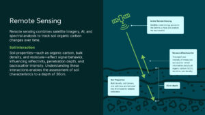
Our models are trained to estimate SOC stocks down to 30 cm—aligned with the depth and methodological rigor required by Verra’s VM0042 standard, the most widely recognized and technically demanding protocol for soil carbon quantification.
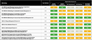
Figure 1: A summary of popular agricultural land management (ALM) methodologies and whether or not they require soil carbon projects to follow the best practices described in The Nature Conservancy’s Remote Sensing Decoder Series. VM0042 is among the most rigorous methodologies for quantifying soil organic carbon levels.
We use Monte Carlo simulations—running 100+ iterations—to generate predictive posterior distributions of SOC change, which lets us report (1) minimum detection thresholds (e.g., 1 tCO2e/acre at 95% confidence), (2) standard deviations for modeled and measured values, and (3) combined model uncertainty when integrating remote-sensing outputs with RothC.
We also meet the requirements of the Social Carbon Standard, which places equal emphasis on scientific integrity and social co-benefits, making our approach suitable for both environmental and community-focused carbon markets.
Our methodology aligns with Verra’s CN0137 guidance on using remote sensing in soil-carbon projects. In practical terms, that means our remote-sensing model must meet three defined performance metrics, and a dedicated Independent Model Expert (IME)—a remote-sensing specialist approved under the program—reviews the model, training data, and validation to confirm those metrics are achieved. This adds an extra layer of independent scrutiny on top of standard auditing.
Carbon removal isn’t a one-time event—it’s a dynamic process. Boomitra’s technology is built to monitor carbon sequestration continuously across the lifetime of each project.
Our regional models continuously ingest new satellite data, while new soil samples are periodically collected to validate and improve model accuracy. This constant, dynamic feedback loop improves model performance and enhances reliability and responsiveness, allowing us to detect changes in soil carbon, including reversals, if they happen.
Every Boomitra project undergoes third-party verification against Verra’s VM0042 and the Social Carbon Standard to confirm compliance with carbon market criteria: additionality (proof that carbon gains wouldn’t have happened otherwise), permanence (long-term storage of carbon), accuracy, and environmental and social co-benefits. Our models are independently validated to these benchmarks, ensuring high-integrity, measurable impact in soil-carbon quantification.
By combining continuous satellite-based monitoring with robust uncertainty quantification and third-party verification, our approach goes beyond minimum compliance—offering buyers a transparent, scientifically defensible solution for high-quality soil carbon removals.
At Boomitra, we believe that powerful technology is only as impactful as the people it empowers. While our platform is built on advanced satellite imagery, AI models, and massive datasets, its true strength lies in what it makes possible for the farmers and ranchers using it.
Through our mobile apps and global support teams, we bring cutting-edge tools directly into the hands of producers—many of whom operate in regions where access to agronomic expertise and climate finance has historically been limited. With Boomitra, these farmers aren’t just beneficiaries of climate solutions, they are drivers of them.
Our apps are designed to be simple, intuitive, and accessible, giving users clear access to the complex insights generated by our models. Farmers can map their fields, submit land records, and enter crop details to get started quickly—without needing a technical background. Once onboarded, they receive real-time, localized advice through Mitra, our multilingual GenAI assistant, which helps them adopt regenerative practices that improve soil health and increase carbon sequestration.
As practices improve and soil carbon increases, farmers can track their progress directly through the app, and receive transparent, secure payments via the Boomitra Carbon Wallet. Behind the scenes, our platform continuously monitors changes in soil carbon using satellite data and machine learning—ensuring that each farmer’s efforts are quantified and rewarded with scientific accuracy.
And when support is needed, our “Carbon Hacking” team—composed of agronomists, scientists, and regional field experts—is there to help. Whether it’s answering technical questions, providing on-the-ground training, or translating AI insights into practical steps, they ensure that the benefits of remote sensing don’t remain abstract, but become tools for daily decision-making and long-term impact.
We measure carbon from space, but it’s the farmers and ranchers on the ground—restoring soil, reviving ecosystems, and sustaining livelihoods—who are at the heart of it all.
Boomitra is already delivering impact at a global scale. We’re working with over 100,000 farmers across more than 5 million acres, using our remote sensing technology to measure soil organic carbon with accuracy and scale.
We’re proud to have developed the first Verra-approved soil carbon project using satellite and AI to measure SOC, but we’re even more proud of what that means for the future: a more inclusive, data-driven, and scalable approach to restoring soils, supporting farmers, and tackling climate change.
Dive deeper: Explore the URVARA MRV white paper and see our methodology at work.
Boomitra’s models meet—and often exceed—the accuracy thresholds required under Verra’s VM0042 methodology. While physical sampling has error margins due to sparse coverage, our AI-calibrated models combine ground-truth soil data with continuous satellite observations to provide statistically validated results. At the project scale, uncertainty in SOC change is typically around 1 ton/acre, and we apply a conservative 10–30% deduction to issued credits to ensure buyers receive results with high statistical confidence. This level of uncertainty—and the corresponding deductions—are comparable to those applied in projects using conventional soil sampling methods.
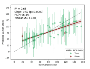
Figure 2: Validation example from Argentina: satellite-derived SOC compared with ground-truth sampling across Boomitra ranches.
In general, the R² values across our projects exhibit a range from 0.10 to 0.70, y the SOC stock estimates are always unbiased (on average, across all samples, they are not too high or too low relative to ground truth).
We use a combination of satellite sources, including Landsat (30m), ALOS (25m), and others. Our models can monitor soil carbon at 30 m resolution in grasslands and 10 m in croplands.
Satellite revisit intervals range from 5–16 days (sensor- and region-dependent). We ingest new imagery continuously and periodically retrain and revalidate our models with fresh soil samples from project sites. For consistency and comparability, we report one registry-grade SOC value per year, aligned to the same season each year to control for seasonal fluctuations and ensure like-for-like year-over-year comparisons.
Each model undergoes Geospatial Bayesian Uncertainty Analysis to assess statistical confidence, identify spatial blind spots, and ensure reproducibility. We provide per-project uncertainty metrics to credit buyers and verifiers.
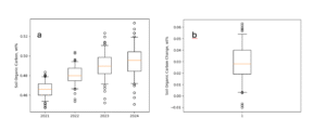
Figure 3: An example of the Minimum Detectable Difference of our technology at one farm in India reveals that the standard deviation in the change over the 3-year period was about 2 t CO₂e/ha, translating to a detectable change of approximately 3.2 to 3.6 t CO₂e/ha at a 95% confidence level. Importantly, for the overall project to be statistically significant, not every farm needs to exceed its own threshold—what matters is that the area-weighted average across all participating farms shows a significant increase.
Yes. Boomitra is the first and only Verra-approved remote sensing solution for measuring soil carbon. Our MRV system is fully aligned with Verra VM0042, the most rigorous global methodology for SOC quantification.
Yes. Boomitra has compiled one of the largest global soil carbon datasets in the world, comprising over 1M soil samples. Each soil sample is geospatially tagged, timestamped, and analyzed at nationally accredited laboratories and FAO-recognized labs to ensure consistent, scientifically valid results. Our data is stratified by soil type, climate, and management practice allowing us to represent variability within project zones, and we continually expand our data collection to improve our machine learning and biogeochemical models.
We measure soil carbon to a depth of 30 cm because it is the globally recognized standard for SOC assessments. This depth captures the most biologically active portion of the soil, where inputs from roots and surface residues are most concentrated. Moreover, the majority of global soil carbon datasets and research studies—used to calibrate and validate our carbon models—report SOC values to at least this depth, ensuring consistency across the databases that inform our remote sensing models. Adopting this standard also aligns our measurements with IPCC guidelines and widely accepted carbon accounting frameworks.
To learn more about how our tech enables high-integrity carbon credits, schedule a call with our team.

EMPRESA
SOLUCIÓN CLIMÁTICA
Al optar por participar, aceptas nuestra Política de privacidad

